Archive
The Mud and the Mist
5 am. I’m sitting on the train to Lewes. Although it is cold and there is a drizzle, I decided to walk the next part of my South Downs Way adventure. Today it will take me on a walk of about 20 km from Lewes via Ditchling Beacon, the highest point of the South Downs Way in East Sussex, to Brighton. It is still pitch black outside. I’m in a good mood, but feel a bit nervous, as it is my first major walk after this long winter. Actually, the winter isn’t over yet. I hope the winds on the Downs won’t be too strong, so I will be able to take some good photographs.
5.47 am. One patch of the sky is really beautiful. All clouds, but with a soft, reddish light shining through them. The day might even turn out just fine.
6 am. Arrival at Lewes. My walk starts here. It is a bit of a struggle to find my way out of town, but once I pass the prison, I am out in the open countryside. The path is steadily leading uphill. In some parts the mud is so deep, it almost reaches my knees. I’m on my own. No one is around. Just me, the sheep and the views over a misty valley. There are still some tiny patches of snow along the way which shows that we are really having a harsh winter.
I reach Blackcap, a local nature reserve owned by the National Trust. The views from up here would be spectacular, if there wasn’t the thick mist lying over it. Still, it is quite impressive, somehow dream-like. This area is supposed to be full of wildlife. I read about Blue Tits and Common Chaffinches living in the thickets, grazing Exmoor Ponies and Roe Deer as well as Carrion Crows flying overhead. But, apart from a few rabbits, I don’t see any wildlife.
Time for a little break. I stop at a triangulation point, but the wind is too cold to sit down. So I just take a couple of photos and walk on.

Triangulation point at Blackcap
The mist is getting thicker. Crows are watching me as I make my way along windswept trees further uphill. Ditchling Beacon shouldn’t be too far away now.
What a change! My path is not going through the middle of a field full of bulls. They are fenced in and I walk along the other side of the fence. From this position they seem to be quite friendly animals, but every time I had to walk through a crowd of them before, it was a little bit, well to be honest, quite scary.
Some cyclists ride past me. They don’t get very far. The mud is just too deep and they are giving up, returning to where they came from.
The Sun is trying her best now, but the mist and the bitterly cold wind is preventing her from sending me some much needed warmth. Ditchling Beacon is in sight now. Just a few more minutes and I’m up there.
It’s a shame, that it is absolutely impossible to take a few good shots here. The wind is too strong and the view is not good either. Anyway, Ditchling Beacon is fabulous with a long history reaching back to the Bronze Age when there was a hill fort standing here which was still visible up to the 1940’s when ploughing destroyed it. Today Ditchling Beacon is managed by the Sussex Wildlife Trust and grazing has been re-introduced to the area. This helped restoring and maintaining the chalk grassland which is one of the rarest habitats in Western Europe.
The wind is getting stronger and colder. I’m wearing gloves and a hat. It just doesn’t seem to be enough. This isn’t a good day for photography. It isn’t even a good day for walking. Still, the walk does me good and, whilst walking on, I’m planning my next walks.
I’m leaving the South Downs Way now. The Sussex Border Path will bring me down to Brighton. Accompanied by the sound of sucking mud I walk downhill and suddenly, I’m up for a surprise. What’s standing there in the middle of nowhere? It’s an Indian War Memorial.
The Chattri War Memorial is situated 150m above Brighton and can only be accessed by bridleway. Some Indian soldiers who fought for the British Empire in World War I were cremated here. It is an absolutely exciting place. Despite my frozen fingers I unpack my camera and take many photos of the place. Wow, now the long walk finally turns into a photo walk which it was intended to be in the first place.

The Chattri War Memorial
To avoid walking through the city, I take a path along the main road and get to Stanmer Park which is really nice with the little village of Stanmer located in it. From there I have to walk only a few minutes to get to Falmer Railway Station from where I take my train back to Hastings.
I walked for 7 ½ hours, almost without having a break. After processing the photos, I kept 22 of them. A couple will be up on my websites soon.
All in all I had a nice day although it was very cold. It made me hungry for more and I will continue my walk on the South Downs Way pretty soon.
Thanks for reading.
Hiking along the River Rhine in Switzerland-Part II
After that great night nearby the Rhine Falls I started early and first walked back to Schaffhausen and then always along the River Rhine. After about 20 km I got to Stein am Rhein where I took today’s photos. The weather was very nice so I slept in the open again. This time right on the shore of the river.
Shortly after Stein am Rhein the river widens up into the Lake Constance and the path gets a little bit hilly with great views. I passed the small towns of Steckborn and Ermatingen before walking along the Rhine again into Germany to reach my destination of Konstanz.
Summary
A great hike quite easy to walk. Most of the time it is flat with only the occasional hill. If the weather wouldn’t have turned bad, I would have walked on along the shores of the Lake Constance into Austria and then again to Germany. But I had done that a few years before and I happily took the ferry to Meersburg from where a train took me home into the Bavarian Alps.
Photos of the Day

The small town of Stein on the River Rhine.

Stein on the River Rhine- medieval houses

Oliver cooking dinner on the shores of the river Rhine.
Hiking along the River Rhine in Switzerland – Part I
Starting Point: Schaffhausen (Switzerland)
Destination: Konstanz (Germany)
What a wonderful hike that is! Starting in Schaffhausen, of course, I wanted to see the famous Rhine Falls nearby. So I started hiking in the wrong direction away from my destination of Konstanz on the Lake Constance in Germany. It is only a couple of hours walk from Schaffhausen to the Rhine Falls and well worth it.
Because I was travelling by train from Bavaria to Schaffhausen it was getting quite late already and I decided to sleep somewhere close to the falls. From a former visit I knew that there is a small half-island just on top of the falls. That was my place to stay. Sitting there watching the river run towards the falls whilst cooking dinner was just an excellent experience and finding a quiet place to stretch my legs in my sleeping bag was no problem at all. I had a wonderful night there although the river got quite noisy.
Photos of the Day
Oliver in Schaffhausen

The Castle of Schaffhausen in HDR

View of Schaffhausen from the River Rhine.

The Rhine Falls near Schaffhausen in Switzerland.
Living in a village in the Bavarian Alps
I lived in three countries in Europe: My native country Germany, my spiritual home England and Spain. In 2003 I moved from the sunny Costa del Sol in Spain to a very small village of only about 80 inhabitants in the Bavarian Alps. Beautiful place, great views over the mountains, but hard to live in with no shops and the next pub a couple of miles away. So the one year I spent there I was walking a lot. I did some great mountain hikes, but also enjoyed the many lakes around there. And of course the nearby world-famous Castle Neuschwanstein. I also made my first experiences with digital photography. Now, many years later, I’m happily living in England again and enjoy not having those harsh winters you get in the Alps. The photo below is from one of my hikes to the lakes in the surrounding area of the Bavarian village of Hertingen near Nesselwang. It is called “Attlesee” and is not that well-known to tourists, but quite a nice place. It was also one of my first attempts in tone-mapping an ordinary jpeg-file.
Photo of the Day
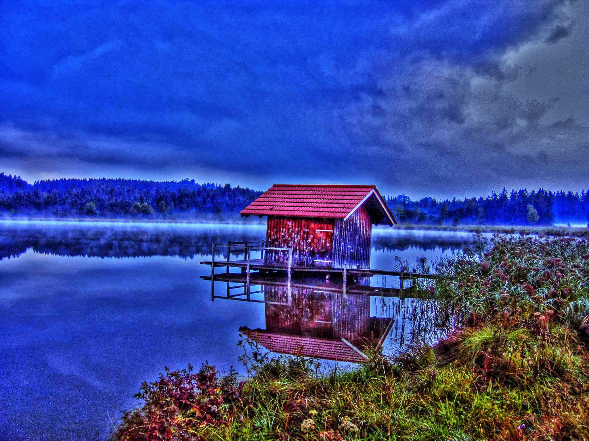
An early morning shot of Lake Attle near Nesselwang in the Bavarian Alps.
The Big November Sweat
It was rather chilly when I left my house to go for a photo-walk this morning, but the sun was shining already on a clear blue sky. I decided to do something for my fitness as well as taking photos and so I went on the rather strenuous walk through Hastings Country Park. Up and down the cliffs for miles, but gorgeous views. First I had the low sun on my side and later on in my back, so it was almost ideal conditions for taking some great shots. I also wanted to experiment a bit.
After a while of going up and down the hills I realised that wearing a fleece and a light windbreaker were just too much. The sun was really warm and that on November 29th. Of course, the walk did its bit as well to me sweating a lot.
At the end of the Country Park at the Fire Hills I had brilliant clear vistas over to Rye and further on to Dungeness. The only bad thing about this was that I saw the nuclear power plant there quite clearly, too. After enjoying the views I went into Fairlight Village with its amazing church which was thankfully open to the public. I took some more shots in there and then walked back the “straight” way to Hastings.
I will have hours of processing ahead of me now. Tonight, or maybe tomorrow.
Questions I asked myself today:
- Is Global warming taking effect more and more?
- When the hell do I get something to eat? I’m f…king starving.
Resolution of the day:
Go out there and shoot, shoot, shoot. Experiment and try not to get sun-burned at the end of November.
Thanks for reading. Feel free to share.
Photo of the Day

Overlooking Hastings Old Town from the Country Park.
In the beginning back in 1967…
…Oliver didn’t know about a rock ‘n’ roll show.
I’ve been processing very old photos this morning which made me think about my first travels. Actually, I can’t remember my very first one when my mum delivered me in a hospital somewhere in Bavaria. I guess, you folks had the same experience at one point and you can’t remember either.
Well, my parents took some photos so I get an idea how I looked liked at that time. These are two of my favourites:


What a smart little boy I was! That image changed radically when I discovered football, heavy metal and punk for myself. I became a real bad boy of Rock ‘n’ Roll. But that’s another story. Back to my first travels. I did a lot of mountain walking from an early age on and I still do lots of walking. Well, it is part of my business as a tour guide and photographer. The next photo shows me and my grandparents somewhere in the Austrian mountains.

Today
Back to today. Although it’s a beautiful day, I’m tied up with computer work. I’m doing really well on fanartreview.com . In the mixed media category I reached rank 118 out of 348 now. So I’m strongly going for the Top 100. In the traditional photography category I’m on 458th place out of 1190. I achieved all that in only a couple of months.
On viewbug.com I achieved 2 awards and 31 recognitions to date. I’m happy with that for I’ve been there for a couple of months only. Have a look, if you like:
http://www.viewbug.com/member/oliverkluwe
Wish you all a nice day.
